Category Archives: Uncategorized

The Risk Paradox: Does Experience Make Us Safer or More Vulnerable?

I originally sat down to write about risk as a way of processing a year with far too many avalanche fatalities. I ended up with far more to say and write than I had planned, and I ended up with something that I felt should get more readership than just this blog. My friends over at Skimo.Co saw value in this and posted it to their site. Thanks to both Tom Diegel and Drew Hardesty for their feedback on this piece.


For many years, I have spent a lot of time thinking about risk in the mountains. What is risk? How can a person minimize risk? How do different people evaluate and perceive risk?   Christian Beckwith’s Ninety-Pound Rucksack podcast is a fascinating account detailing the history of the 10th Mountain Division. However, each podcast ends with “….without risk, there is no adventure.” This has never quite sat right with me. Is it really true that adventure cannot exist without risk? How much risk is necessary for something to be an adventure?  

People often describe others as having a high or low risk tolerance in reference to the risks they accept. In Luc Mehl’s recent Risk Ramble podcast, he argues there is no such thing as risk tolerance – only risk perception. For example, a Class V whitewater kayaker perceives the risk of paddling a Class V river as low, whereas a Class II paddler would perceive the risk of paddling that same river as high. Does the Class V paddler have a higher risk tolerance? Probably not; they just perceive the risk differently. To better understand risk perception, a person needs to understand what risk is.

Risk is always present – in the mountains, driving down the highway, in personal finances, and in most aspects of our lives. Let’s define risk before diving into how it relates to backcountry skiing. There are many complex definitions of risk based on various industries and activities. In the avalanche world, Grant Statham  (Avalanche Hazard, Danger, and Risk – A Practical Explanation) defined risk as:

In this equation, “Hazard” is usually the easiest to define. Triggering an avalanche, terrain, weather, hitting a tree, and getting hurt are all simple examples of hazards. 

Exposure is the main element you can control. It is where the hazard exists and how long we are subjected to it. Avalanche instructors teach that no matter the question, terrain is the answer. For example, if the hazard is a persistent weak layer (PWL) on the north-facing slopes, we can choose to ride south-facing slopes, thereby eliminating our exposure to the hazard and reducing our overall risk.

Vulnerability, on the other hand, is more difficult to define and control.  It refers to how susceptible we are to the impact of a hazard. Returning to our example of a PWL on a north-facing slope, if we choose to ski a 35-degree north-facing slope, we have already accepted exposure. However, our level of vulnerability depends on our preparedness. Knowledge and skills are one of the best ways to reduce our vulnerability.  To reduce vulnerability, we need to continually seek learning opportunities and then practice what we learn. Gear can also reduce vulnerability, but this doesn’t help until you are already impacted by the hazard. If we enter avalanche terrain without proper rescue gear— transceiver, probe, and shovel—we are highly vulnerable to the consequences of an avalanche. Conversely, if we wear a transceiver, carry rescue gear, and use an avalanche airbag, we cannot reduce our exposure, but we can reduce our vulnerability by increasing our ability to survive and respond effectively in the event of an avalanche.

While this might be “a practical explanation” it is still not simple. To measure the risk, one needs to think of all the hazards, the exposure (what is this again?), and the vulnerability (isn’t this very subjective to each person and also to what is going on in their lives separate from this specific risk.?). To simplify risk evaluation in the field, I often use the likelihood vs. consequence matrix:
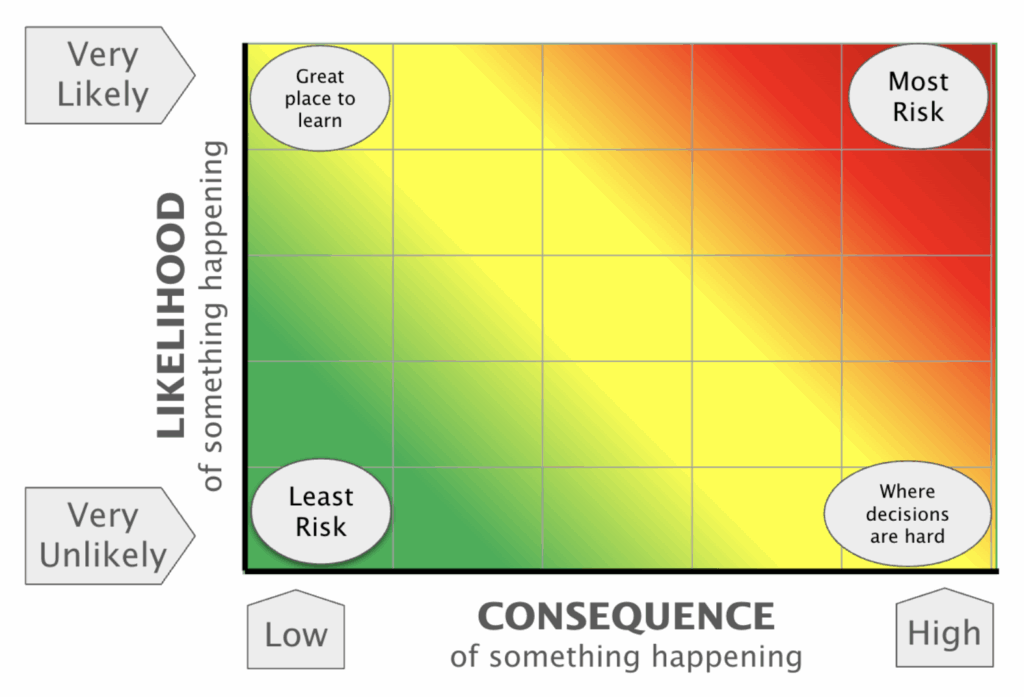
This matrix makes risk assessment more manageable. Regardless of the risk framework used, these concepts align with Luc Mehl’s idea of risk perception vs. risk tolerance.  

While working at the Utah Avalanche Center (UAC), I remember UAC Forecaster Greg Gagne discussing risk. He had been talking to a non-backcountry skier friend and mentioned he was risk-averse. His friend immediately disagreed. “Greg, you spend lots of time in the mountains backcountry skiing, running, and climbing. Those are all risky activities. How can you say you are risk-averse?” At the time, Greg’s comments really resonated with me. Now, relating Luc’s recent podcast about risk tolerance vs. risk perception to this discussion several years ago really tied together the concepts of risk. Luc’s whitewater example mirrors Greg’s discussion about risk with his friend. Those of us who spend significant time in the mountains perceive risk differently than those who do not. This realization led me to question: Does our risk perception change over time? With experience? With education? With external influences? How can we ensure our perception of risk remains clear? As we gain experience, are we becoming blind to risk, or are we becoming risk-savvy – adept at identifying and mitigating it?

What does it mean to become risk-savvy? Being risk-savvy in the backcountry means more than just assessing hazards; it requires continuously refining our ability to recognize, evaluate, and mitigate risk. It means developing skills and acknowledging when conditions are beyond our skill set, when external factors like fatigue or group dynamics cloud our judgment, and when the reward simply isn’t worth the potential consequence. Risk-savvy travelers cultivate humility, understanding that experience alone does not grant immunity from accidents. They adopt a continuous learning mindset, adapting strategies based on conditions, new research, and past mistakes. They seek knowledge from their own experiences and those around them, embracing mentorship, collaboration, and honest self-assessment. Ultimately, being risk-savvy is about making decisions that allow us to keep adventuring—again and again.

What are some skills an adventurer needs to develop to become risk-savvy? These skills are far and wide and include things like

  • Mountain skills such as terrain management, navigation, and weather
  • Rescue skills, including avalanche rescue, first aid, and self-evacuation
  • Interpersonal skills to prevent group dynamics challenges and to understand heuristic traps that can impact you and your group

During the 2024-2025 season, Utah has already seen five avalanche fatalities. This is almost twice our annual average of 2.7.  Two of these fatalities involved solo travelers in avalanche terrain on “High” danger days. One was a solo traveler on a “Considerable” danger day. The other two were parties of two in avalanche terrain on days with  “Considerable” danger.  With these incidents, it is hard not to evaluate our own perception of risk.
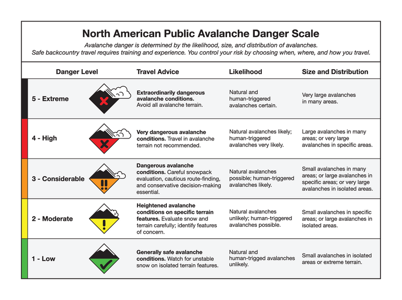
On “High” danger days, experienced backcountry travelers typically perceive the risk as high, while those without avalanche training often avoid the backcountry altogether. On those days, travel advice is to stay out of avalanche terrain (on or under slopes, >=30o). “Considerable” danger is more nuanced – it is a 3 out of 5 on the danger scale. That’s right in the middle – doesn’t that mean it is fairly safe? Isn’t that average danger (it is the median, after all)? Not quite. By definition, “Considerable” danger means human-triggered avalanches are “Likely”. The word “Likely” feels much stronger than a 3 out of 5. Imagine if we described car crashes the same way: “There is a 50% chance you will die in a car crash today” versus “It is likely you will die in a car crash today.” Neither sounds good, but 50% feels better than “Likely.”

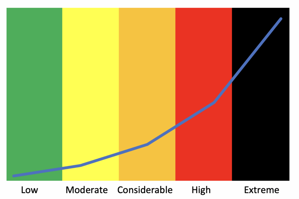
In avalanche classes, I like to discuss the danger scale being exponential rather than linear. “Considerable” isn’t just a 3 but rather an 8. Recognizing this exponential increase helps put the increasing risk into perspective. “Considerable” isn’t just slightly more dangerous than “Moderate”—it’s significantly more dangerous.
This season’s fatalities in Utah were experienced backcountry travelers. Based on their experience, they should have been risk-savvy. So what happened?  What was their risk perception? Were they caught in a heuristic trap, believing their experience allowed them to beat the odds? Did familiarity with the terrain cloud their judgment?

Research indicates that the average age of avalanche victims is increasing (How old are the people who die in avalanches? A look into the ages of avalanche victims in the United States (1950–2018)), as is the level of avalanche education among victims  (TAR 40.3, page 36). The backcountry is a “wicked learning environment“—one where feedback is often unclear or delayed.

Could this environment play a role in these avalanche fatalities? Does accumulating years of accident-free travel in the backcountry negatively impact risk perception, leading to the increasing age of avalanche accident victims?

We have ample time on the skin track which is a great time to prioritize positive group discussion from the avalanche forecast to concerns for the day. Luc proposes four simple prompts to help identify risk.
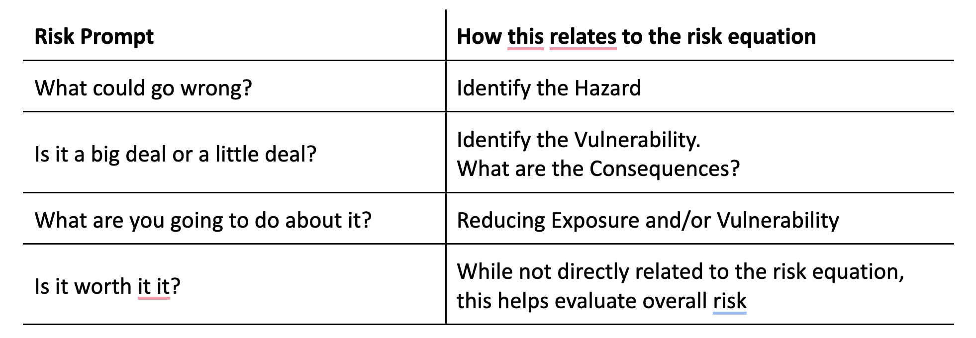
Returning to the likelihood vs. consequence framework: The avalanche forecast helps us assess the likelihood, but what about consequences? Several factors come into play. Some examples include:

  • Terrain complexity: Are there terrain traps below you (trees, gullies, cliffs)?
  • Rescue skills: How proficient are you in avalanche rescue, first aid, and survival techniques?
  • Solo travel: Traveling alone increases consequences. Tom Diegel has written a thoughtful blog on solo travel—greater consequences mean risk should be adjusted accordingly.
  • Remoteness: How far are you from rescue? How long would it take for help to arrive?

Besides avalanches, what other risks exist for your day out? Hitting a tree, tweaking a knee, breaking gear, getting lost – each carries its own likelihood and consequences.

Suddenly, risk assessment becomes quite complex. You must decide which levers to pull—reduce likelihood by avoiding avalanche terrain or specific problem areas, or reduce consequences by improving skills and preparation. Either way, moving further from the high likelihood/high consequence red zone is key.

With so many variables, it’s easy to misjudge risk. So perhaps it is true that “there is no adventure without risk.” However, becoming risk savvy and understanding and managing that risk is what allows us to keep adventuring.

One Year at the UAC

One year ago, I made the bold leap from the comfort, stability (and stress) of the technology consulting world for a new challenge. I began my role as Executive Director (ED) of the Utah Avalanche Center (UAC) nonprofit. I now have my first year under my belt and it has been such an amazing experience. I took on this challenge for not only a life change but also for the chance to make a difference in a sport that I love. I started backcountry skiing when we moved to Utah in 2002 and quickly developed a passion for avalanche knowledge and education. Upon becoming friends with Paul Diegel (the departing ED), I developed a huge respect for what the UAC does and I hoped to be a part of the organization at some point in my life. I think that deep down, I have always wanted a career that would help people and be something that I was passionate about at the same time. 

IMG_1574
One of the too many to count events we provide awareness and education materials at.

What has it been like to be the ED? For starters, I have never worked with such a passionate group of people. The entire staff is whole-heartedly dedicated to the mission of the UAC and is committed to our success. This is such a change from the corporate world where so many people are just ‘filling a seat’.

Brewvies-Aspen-Extreme
Dedication is dressing up for a throw-back ski movie (Aspen Extreme) fundraiser.

I have learned so much over the past year. One of the great things about a small nonprofit is that every day is different. You can be writing a grant, talking with a donor, fixing a trailer, and giving an avalanche awareness presentation all in the same day. Payroll, insurance, employment law, hiring, teaching, grant writing, project management and the list goes on. These are just a few things that fill my days.

IMG_1424
Bourbon tasting and avalanche education – the perfect combination.

IMG_1142
On-snow avalanche classes.

I have also had the privilege to meet many, many amazing people that share our passion and support our cause. These people range from donors, to educators, to the staff of other avy centers.

I have also learned new skills, like riding a snowmobile in the mountains. Turns out this is MUCH harder than I had imagined.

IMG_1267
Patient instructors

One of the big questions I get is, what are you going to do in the summer. It is often hard for people to believe, but the ski season is actually not our busiest time of year. Summer consists of special projects (this year we are rebuilding our website and building 5 online learning modules) as well as planning our fundraising events, the Utah Snow and Avalanche Workshop, and getting all of our winter classes scheduled. Fall is event season. We have several fundraisers ranging from as small as 50 people to as large as 1,000 people, we have educational tables are numerous events (ski sales, outdoor events, etc), and we have our large 900+ person Utah Snow and Avalanche educational workshop, The list goes on.

What a year it has been! As we ramp up for the upcoming season, I am excited to be able to take what I learned in my first year, help keep people safe in the backcountry, and continue to grow our fantastic organization.


Wild Idaho SUC (Standhope Ultra Challenge) Stage Race – 12-15 Aug 2015

My friend Mindy ran the Standhope 60k last year and said it was a fantastic race and really recommended it. I looked it up this spring and found that Ben, the race director, was now doing a stage race that included the 60k as the final stage. I spent time in Idaho in 1999 for work and Chad and I did a week backpacking trip in the Sawtooth Mountains during that time. We also did a backcountry ski hut trip there several years ago. I knew this is a beautiful location and we have not spent much time there so I was excited to check it out.

The stage race format has always intrigued me but the races are usually super expensive and I have not been able to justify the high cost. I also do not have a desire to be running overnight this year but still want to train for long distances and explore new territory. This seemed to be a great alternative to a 100 mile race this year. The Standhope stage race stated that it included over 88 miles and 26,000 vertical in 4 days. The stage race ends with the last race logging 60k and 11,000 vertical.

I trained for this race similar to a 100 mile race since my normal training for a 100 mile race includes many back to back long runs. Our weekend in the Winds were great trainign. I knew this race format would be very enjoyable to me since I really like running those distances and the challenge of back to back runs.

I drove to Ketchum on Tuesday and “set up camp” which just means park the truck. My camp views were spectacular.

1IMG_2609

Views from my bed in the back of the truck.

1IMG_2610

Home sweet Truck. There was a stream just behind those trees to soak and bath.

1IMG_2612

Location of some of the other stage racer’s tents and camper a short walk away.

There were only 18 people racing the entire stage race. There were 10 men and 8 women. Sue Lee was the only other UT person and others were from ID, WA, WI, MI, GA, and Alberta, Canada.

Day 1 – 18.87 miles, 5600 vert, 4h 27m:

We started out Day 1 of the stage race by getting delayed by the local wildlife on the drive up to the start. The sheep heard delayed our start by 15 minutes.

1IMG_2607

Sheep heard that delayed getting to the start of the first race.

It was a challenging but beautiful loop that topped out at an elevation 9500’. This was one of my best days of racing. I felt great! The only downfall is that the second climb was extremely hot and exposed and the majority of us ran out of water before we finished.

Day 1 Pioneer Cabin Loop

Day 1 map and elevation profile.

1IMG_2617

There was great scenery on Day 1. Photo taken by Sue Lee.

I spent the afternoon getting rehydrated, soaking my legs in the creek, resting, and preparing for the next day.

Day 2 – 17.92 miles, 4100 vert, 3 h 55m:

Day 2 was a point to point run. We all met near the finish location then we were shuttled to the start of the race. This day we stayed a little lower only topping out at an elevation of 8500’. This trail had a lot of hikers and must be a popular trail in the area. Starting around mile 6 I had issues with my ears clogging and felt like there was fluid in them. I have had this problem sporadically and more often lately. It is quite concerning since it makes me quite dizzy and sometimes nauseous. Due to this I wasn’t able to move as fast as I wanted to and really had to slow down near the end of the race.

Day 2 East Fork Baker Creek to Oregon Gulch Trailhead

Day 2 map and elevation profile.

1IMG_2618

Running down the trail with Thomas.   Photo taken by Sue Lee.

As soon as I was finished and had my recovery drink I headed straight into town and went to the pharmacy. The pharmacist recommended pseudoephedrine and drops for my ears. I immediately took the meds and put the drops in my ears and it was instantly better so I felt good about the next day’s race. I spoke with Chad, caught up on email, and had a great Mexican meal. I then headed back to camp and prepared for the next day’s race.

Day 3 – 13.72 miles, 4400 vert, 3h 13m:

The 3rd day of racing was one of the best days. This was the shortest day and we were all going easy since we had our really big day the following day. We drove to the starting point of the race and our race started by running on a dirt road for approximately 1 mile to warm up. Then we started the big climb. The majority of the climb was not steep but was very technical so not very runnable. Sue and I stuck together the whole time and had a great time chatting and getting to know each other better. At the top of the ~3500’ climb we had amazing views and a preview of what the next day would bring. My ears started plugging around mile 9, I put the ear drops in a number of times and thankfully had immediate relief after using them.
Day 3 Ketchum via High Ridge to Park Creek CG

Day 3 map and elevation profile.


1IMG_2619

I’m taking in the views before running across and down the mountain. Photo taken by Sue Lee.

This was a great day of racing. After getting back to the truck I again went into Ketchum to talk with Chad, catch up on work email, and refuel. I then drove up to the start of Saturday’s race. I got there, checked in, and we had the pre-race meeting. It was great to see friends that had come to race those races. Ben had a great turn out with over 160 racers. I ate another small dinner, had a beer, finished packing my drop bag and finish line bag and went to bed early.
Day 4 – Standhope 60k – 40.94 miles, 12,000 vert, 11h 01m:

I woke up at before 5a to ensure I had enough time to get ready and eat which was more than enough time. We had a 6a start time and it was still dark and really cold as we headed out of Park Creek.

Standhope 60K 2015

Elevation profile of the Standhope 60k.

The first climb and decent was great. The temperatures were very cool and I was just a little chilled with arm warmers and gloves on. I cruised into the first aid station, filled up, and headed across the bridge and into the cow pasture. That is where things started to go wrong. There was a junction that did not have any flagging but we saw one flag going through a stream in the far distance. We ran there to check it out, kept running on that trail then realized that this couldn’t be the way. We backtracked and headed up the other trail. We kept thinking that we had to be right but there were absolutely no flagging all the way up the climb. A few 7AM (the non-stage race 60K runners started at 7AM) starters were passing us then and those who had done the race said it was the right way. We got to the top of the 2nd climb and really had no idea where to go since there were still no course markings. We knew we had to go down but not sure how since those that I were around at that point had not done the race before. We traversed on a side hill and I kept another racer (and friend from Salt Lake City) in my view and missed the turn (unmarked) to go down. I backtracked and finally got on the right trail and ran all the way down to the next aid station still not knowing for sure if it was the right trail since it was not marked at all. In the end about 9 miles of the course were not marked at all and at the 20.4 mile aid station my watch read over 23 miles. Not great for the mental. I felt physically good and started the next huge climb. It was steep and unrelenting, technical, and amazingly beautiful.   It topped out at over 11,000’, had a short downhill, and went up to close to 11,000 feet once more before the next long downhill. I tried to get my leg turnover to keep speed up but knew I was slowing down due to all of the miles on my legs from the week. I hit the next 1000’ climb and felt like the brakes came on. I had not been able to eat much for a while at that point and my ears were plugging. I put drops in a few times during that climb and just put my head down and motored up that steep hill as fast as I could. At that point my watch read close to 40 miles and knowing the race was supposed to be less than 38 was a little demoralizing. I cruised down the other side and it wasn’t long before I could hear the finish line and ran as fast as I could to finish.
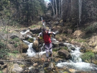
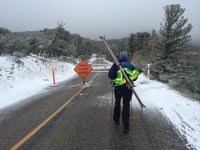
I was bummed that it took so long to do this race but going almost 4 miles extra and all the time trying to figure out where to go really increased my time on the course (off the unmarked course in this case).

My fellow stage racers were all such wonderful and fun people and I look forward to seeing them at other races and running with them in the future. I had just recently met Sue and we were happy that we are very similar paces and I look forward to running with her more in the future as well.

I ended up finishing 3rd place for the women and 6th place over all for the stage races. Results can be found at https://ultrasignup.com/results_event.aspx?did=29442.

Total miles: 91.43

Total vert: 26,100

1IMG_2622

Beautiful handmade belt buckle with flowers from the local trails.

Thanks to Ben for putting on a great race.

The stage race was really a great event with lots of fun people and beautiful and technical new trails. I can’t wait for my next one.

Getting Aced by The Deuce

Ever since running the first section of the Maah Daah Hey trail through the North Dakota Badlands, Emily and I have wanted to spend more time running there.  When the second section known as ‘The Duece’ was finished (I believe just last fall) I knew it was time to plan on finishing the rest of the trail and then putting together plans to run the entire ~145 miles in 1 push.

Emily and I decided we would do this during our trip home to visit family over July 4th.  July isn’t the best time of the year to head out on a 47-mile run through the treeless, shadeless Badlands, but how bad could it be? The only day we could do this ended up being the hottest day of the year so far with temperatures hitting 85F by 8:30 AM and topping out at 96F in the afternoon. We quickly learned that it could be REALLY bad. The weather put the decision to run The Duece into my ‘Top 5 Bad Decisions Ever’ list (running the Highline Trail alone in bad weather may top this list).

The start of Maah Daah Hey The Deuce

Our morning started out amazing with fog in the low draws and 57F temps.  We made great time on the first 13 miles before meeting Emily’s parents at our first ‘aid station’. The trail was amazing. Well marked, in great shape, and perfect for fast running.

Early morning light on The Duece

One of the ~20 gates on The Duece

The amazing views on The Duece

The amazing views on The Duece

The amazing views on The Duece

The amazing views on The Duece

Our great crew at Plumely Draw

By 8AM, an hour into the next section, it was starting to get warm. We slowed our pace to account for the heat and increased our fluid intake (from drinking every 15 minutes to drinking every 10 minutes). The trail and views continued to be amazing. We were seeing cattle, pheasant, pronghorn, rabbits, and luckily only 1 rattlesnake. By mile 24.5 at Bear Creek, our 2nd ‘aid station’, we were really starting to get cooked.

The amazing views on The Duece

The amazing views on The Duece

The amazing views on The Duece

Emily had developed plugged ears from congestion and sweat and decided to sit out the next section of 7 miles to Tom’s Wash. My pace to Tom’s Wash dropped significantly as the temperatures approached 90F. Instead of the 1.25 hours I had planned on this section, it took me over 1.75 hours for this section and I was completely cooked when I got there. I sat down and drank about 2 L and dumped another couple over my head.

The only things we shared the trail with

The amazing views on The Duece
The amazing views of the Badlands on The Duece


Even with 2 coats of sunscreen, I was starting to get burnt so I put on another thick coat and followed it with a healthy dose of DEET to help keep the nasty, persistent horse flies away and then I headed out on the next 8 mile section to Third Creek. This was an amazing section that was almost completely ‘cross country’ just running trail marker to trail marker. I made it about a mile into this section and started to completely melt down. I was suddenly no longer sweating, unable to run at all, and struggling to maintain any type decent of walking pace. After 1.5 hours I was out of water having drank 44 oz and I was still 3 miles from my crew. Emily was going to run out to meet me part way so I was counting on this. I was starting to have trouble following the trail markers and getting clumsy and dizzy from the heat and dehydration. I knew I was walking a fine line. I had to keep moving, but couldn”t push it. I came to Hanley Creek and it thankfully had a couple pools of rusty red and yellow water (or rather a mixture of cow piss and water based on the smell). I slid down the steep sandy bank and sat in the 8” of water soaking my legs up to my waist. I sat for 5 minutes getting my core temperature down and then climbed back out and headed on. I felt like a new person. I was still out of water, but at least felt good enough to maintain a good walking pace for a while. After another 15 or so minutes I met Emily and she had 2 bottles of water. I quickly drank 1 and nursed the other. We hiked the next mile to where the trail crossed a road and were met by Emily’s dad who had driven up looking for us. We bailed with 1 mile left to Third Creek and called it quits. The temps were now in the mid 90’s and there was not a cloud in the sky to offer any reprieve. I wasn’t happy to be quitting before Burning Coal Vein (the end of the trail), but there was not safe way to continue in those temperatures after already getting so dehydrated.

We enjoyed the shade of an old cottonwood tree along the creek (the largest tree I have ever seen in the badlands) while I recovered. I had 3 packets of Recoverite, another few liters of water, some food, and a beer. After about 30 minutes I was feeling good after having cooled down and rehydrated. It was tempting to head out for the next section, but we knew what the results would be so the last 9 miles will be saved for another time.

It was an amazing run and we couldn’t have done it without Emily’s parents being a great crew for us. One of the most amazing things of the run is that we ran for 9 hours and didn’t see another person the entire time. It is so great to be able to have long time of solitude in such a beautiful place. With a detailed GPS track for all but the last 9 miles of the ~145 miles of trail, I am excited to get back and link it all together. An early June attempt would be great as the temps would be cooler and the days long (less than 6 hours of darkness).

Spring Skiing Fever

I have been slowly getting back into running after my back and leg issues over the winter.  This means I am only running a couple of times a week and only short distances (my longest run has been 10 miles).  Since I am not able to run long distances yet, I have been keeping my ski season alive.  We have had a great spring with over 18″ of snow falling from 07-11 May.

As I mentioned in prior posts, spring is always a fun time as you can get into areas I usually don’t feel comfortable on in mid-winter (due to avalanche conditions).

On 03 May, Mark Christopherson and I skied the NW Couloir of Twin Peaks. This is a great line and one of the most visible ski lines from the Salt Lake Valley.  The approach to this is long (5300′), up Broad’s Fork to the summit of Twin Peaks.  After skiing the shot, you can either skin back up and ski down Bonkers and Broad’s or make it an adventure by exiting out Deaf Smith Canyon.  In the spring, Broad’s is typically too warmed to be safely skied (at least for me) so I enjoy the fun of the bushwhack out Deaf Smith. On the approach Mark and I were lucky to be able to start skinning (sort of) at the bridge up Broads.  We had great snow for the climb.  For the descent, wehad variable snow, but we were able to ski 4100′ which limited our walking/swacking to only the last 2000′ descent.

Here are a few photos of our Twin Peak ski (click on image to enter slide show mode)

The following week, Chip invited me down to Wheeler Peak in Great Basin National Park.  Wheeler Peak is the second highest Peak in Nevada at 13,064′ (although the highest peak is not technically a peak since it is a sub-peak of a peak in California).  I could’t pass up the opportunity to ski a big peak.  It was also a rarity for Chip to be able to get away for a night and not having skied with him much lately, I jumped at the chance.  We left after work, drove the 3.5 hours and camped just outside of the park.  We were accompanied by Roland, a friend of Chip’s, and none of us had done a significant amount of research into the area.  We knew 3 good ski options off of Wheeler Peak and 3 more off of neighboring Jeff Davis Peak.  We had hoped to ski a shot off each peak.  We camped close to the entrance of the park and were woken a couple hours after going to sleep with a very wet tent.  We fixed a few items and restlessly slept a few more hours waking up at 5:30 with everything pretty wet.  We knew when we left SLC that the weather was not looking good, but we figured we had the time we should go for it.  Waking up wet, we were starting to second guess ourselves.  We packed up a wet camp, found a shelter to cook breaky under and talked ourselves into it.

None of us are sure if it was a good idea or not.  The snow levels were high, we were left with a 4 mile road walk to the trailhead where there was enough snow to skin, then we spent a lot of time skinning through rocks.  We had little to no visibility the entire day.  In fact we were never able to actually see Wheeler Peak and had to check the GPS to ensure we were actually standing on it.  We picked our way down through the rocks for the first 1200′ before getting into the NE couloir of Wheeler.  The snow was variable at top, but very good down low.  We enjoyed the turns and eventually hit the summer trail again where we had to skin back to the road for the long walk back to the car.  We had high ambitions that since the  weather was so back maybe we could ski part of the road, but those were short lived and we had a long walk ahead of us.

The storm that dampened our Wheeler Peak day made for a great weekend of skiing in the Wasatch.  One of the best things about spring skiing is that most people have given up on skiing so you can have the Wasatch all to yourself (almost literally).  Tom D and I headed out Saturday morning with no specific plan and ended up having an amazing day.  We arrived at Alta to find no skin track up Flagstaff at 8AM (in mid-winter after a storm there is a skin track up Flagstaff by 5AM).  We made a run down Flagstaff in great snow, climbed up and made another great run into Days Fork.  We decided the Hallway would be our next stop and had another set of first tracks there.  Climbing up Cardiff from the bottom of the Hallway, the visibility was poor, but we still had the place to ourselves so we broke a trail up Ivory Flakes.  When done we were trying to determine our exit and Tom mentioned skiing Holy Mole.  Neither of us had skied this so we thought we better try this out.  After missing the entrance our our first attempt and booting out, we both loved the steep shot.  After a quick skin to Pole Line Pass, we finally crossed another set of tracks to ski back down to LCC.

Saturday Emily and I celebrated our 15th wedding anniversary with an amazing meal at Gliterind at Deer Valley followed by a leisurely Sunday morning.  I finally left the house a little after 9 and eventually met up with Eric and Jackie for a few laps.  The weather on Sunday was full on winter with nuking winds, snow, and cold temps.  Not the standard spring skiing conditions.  This made for some tricky snow conditions to find snow that was not wind affected, but we finally found some great snow in West Bowl of Silver Fork.

According to the forecast, this is likely our last storm of the season in the Wasatch.  With over a 100″ base, we should have at least another 3-4 weeks of good skiing.  Eric, Nick, and I are also planning a volcano tour where we hope to ski 4-5 volcanoes in the same number of days (Rainier, Hood, Adams, St Helens, and Jefferson).


It’s a Wrap – 2013 Powder Keg

Reposted from my 2013 Wasatch Powder Keg Synopsis

Wow, what a week. Over the summer, we decided that it would be great to try to put together a 3 day race weekend that could be a destination race for people. For out-of-towners, it can be hard to justify a 6+ hour road trip for a single race, but with 3 races, that might be easier to justify.  We ran the idea past Brighton and they were on board.  We then started reaching out to the local skimo community to round up help in making this event a reality.  Eight months later, here we are with the races a couple of days behind us and (at least for us) still trying to recover from minimal sleep during race week.

Race preparations start in July, they hit the first peak in the fall with sponsorship, then quiet down to a manageable state until January.  From OR Show on, things are in full swing, but nothing compares to the how busy race week is.  This year was especially busy with course re-routes for Saturday and course finalization for Sunday.  We had 10-12 volunteers on the course starting on Wednesday to set the flags and skin tracks and make sure all conditions were safe.  With all the help we had, course setting went very smoothly and we had everything in place and the Friday Sprint course setup about 1 hour before the start.

Digging out the transition platform for Sunday's Team Race
Digging out the transition platform for Sunday’s Team Race


We had a trial sprint-relay in 2012 and people enjoyed it, so this year we decided that the sprint could fill Friday afternoon.  We had 34 racers for the sprint.  We held time trail qualification round followed by a final snow-cross style round.  It was a lot of fun to watch the racers complete the 300′ climb (with a booter) and descend the gates in under 3.5 minutes.

Sprint Podium

Men

  1. Jason Dorais – 0:03:21
  2. John Gaston – 0:03:24
  3. Luke Nelson – 0:03:29

Women

  1. Gemma Arro i Ribot – 0:04:29
  2. Marta Riba – 0:04:36
  3. Meredith Edwards – 0:05:08

Gerard Garreta of Catalunya Finishing the Sprint Race

Gerard Garreta of Catalunya Finishing the Sprint Race

The Sprint race was followed by the traditional pre-race briefing ensuring everyone was aware of the course, course dangers, weather, and avalanche conditions.  We have been organizing the race for 5 years and this was the first year with bad weather.  We knew we would need to be out on course at 4:30AM breaking the trail for the racers, but we weren’t sure what the winds would do overnight and what our actual avalanche danger would be.  Andy Paradis and I were out early flagging the first climb and breaking a trail (which would only get blown in before the race started).  The winds were strong, gusting to over 40mph on the ridge tops.  We were constantly talking to Max (head of Brighton Snow Safety) as they did their morning control routes.  Andy and I had ski cut and cleaned out Brown Spot into Hidden Canyon and knew it was safe.  At 7:20 with 10 minutes before the race start, we were still 20 minutes from the top of Great Western breaking the trail out of Hidden Canyon we made the decision to push the race start back 30 minutes.  The Brighton Patrol had held the volunteers at the top of Great Western until they finished their Snake Creek routes.  Andy and I still needed to clear the Preston Peak and Snake Creek Canyon areas before we could get volunteers into those areas.  We pushed to the top and headed over to those areas.  A traverse from the Snake Creek Express lift to Preston Peak confirmed that area safe.  A quick powdery descent into Snake Creek Canyon also confirmed that area.  Our volunteers were ready to go.  The volunteers had a tough morning with the cold and blustery conditions.

Powder Keg Start
Powder Keg Start


The race went smoothly with Luke Nelson going hard and breaking trail 2,000′ to Clayton Peak to win King of the Mountain.  Gemma Arro i Ribot took the Queen of the Mountain title for the women for the second year in a row.  The skiing for this year’s race was good with 4-6″ of new snow.  We were expecting finish times of under 2 hours, but with the new snow it was a bit longer.

Powder Keg Podium

Men’s Race

  1. Max Taam – 2:14:03
  2. John Gaston – 2:14:27
  3. Tom Goth – 2:14:50

Women’s Race

  1. Gemma Arro i Ribot – 2:30:48
  2. Marta Riba – 2:42:29
  3. Meredith Edwards – 3:00:49

Men’s Heavy Metal

  1. Eric Dacus – 2:53:43
  2. Erik Syrstad – 2:57:23
  3. Spencer Peterson – 2:57:25

Women’s Heavy Metal

  1. Katie Ronsse Libby – 3:19:04
  2. Emily Sullivan – 3:20:35
  3. Sarah Cookler – 3:21:28

Men’s Recreation

  1. Fabien Beaufils – 1:39:27
  2. Andrew Schmidt – 1:40:50
  3. Brandon Ott – 2:00:55

Women’s Recreation

  1. Emily Urlacher-Kirkham – 2:39:09
  2. Jean Marie Wheeler – 2:41:20
  3. Deborah Wagner – 2:56:34

Luke Nelson was generous enough to hold skimo clinics after the awards ceremony and raffle where he focused on transitions, skinning, and other skimo techniques.  The clinics were well received by the dozen or so participants.

On Sunday 38 people competed in the first ever Technical Teams Race.  The weather was great with sun peaking over Mt. Millicent soon after the race start.  We spent a lot of time putting together a long, technically difficult course for this race and based on racer feedback, we succeeded.  The key aspect of this race was the roped section up the Elevator requiring the use of harness, via ferrata, and an ascender.  This was followed by a 50 meter rope down climb using the via ferrata kit for safety.  The Sunday course measured around 8,800′ of ascent and 14 miles!  From the feedback we had, people loved the course so we hope to have it back again next year.

On the rope in the Elevator

It was great to watch this race unfold with Max and John fighting hard to keep ahead of Luke and Tom.  The 4 were within 30 seconds the entire day.

Max & John fighting to keep ahead of Luke & Tom at the base of Clayton Peak booter

Men’s Technical Teams

  1.  Max Taam / John Gaston – 3:37:13
  2. Luke Nelson / Tom Goth – 3:38:44
  3. Byran Wickenhauser / John Brown – 3:53:58

Women’s Technical Teams

  1. Gemma Arro i Ribot / Marta Riba – 4:38:11

Co-Ed Technical Team

  1. Emily Sullivan / Brent Mitchell – 5:47:06

It was amazing that after 3 days of racing with over 15,000′ ascent and more than 20 miles, the top 3 overall men were only separated by 2.5 minutes.

Triple Crown

Men’s Overall

  1. Max Taam – 5:54:47
  2. John Gaston – 5:55:03
  3. Tom Goth – 5:57:10

Women’s Overall

  1. Gemma Arro i Ribot – 7:13:29
  2. Marta Riba – 7:25:14
  3. Emily Sullivan – 9:14:05

It was an great accomplishment for those to complete all 3 days of racing so a big congratulations for those who completed the entire triple crown.

First Last Sprint PowderKeg Tech Team Total Time Place
Max Taam 00:03:31 2:14:03 3:37:13 5:54:47 1
John Gaston 00:03:23 2:14:27 3:37:13 5:55:03 2
Tom Goth 00:03:36 2:14:50 3:38:44 5:57:10 3
Luke Nelson 00:03:29 2:18:57 3:38:44 6:01:10 4
Bryan Wickenhauser 00:03:47 2:18:13 3:53:58 6:15:58 5
Jon Brown 00:03:50 2:23:34 3:53:58 6:21:22 6
Gerard Garreta 00:03:43 2:22:25 4:03:30 6:29:38 7
Teague Holmes 00:04:24 2:25:42 4:03:30 6:33:36 8
Eric Bunce 00:04:05 2:28:43 4:10:44 6:43:32 9
John Curry 00:03:56 2:33:41 4:09:26 6:47:03 10
Nicholas Francis 00:04:40 2:37:45 4:10:44 6:53:09 11
Robert Woerne 00:04:25 2:40:45 4:28:13 7:13:23 12
Gemma Arro I Ribot 00:04:30 2:30:48 4:38:11 7:13:29 13
Marta Riba 00:04:34 2:42:29 4:38:11 7:25:14 14
Spencer Peterson 00:03:58 2:57:25 5:44:49 8:46:12 15
Stu Johnson 00:04:41 3:11:07 5:32:15 8:48:03 16
Emily Sullivan 00:06:24 3:20:35 5:47:06 9:14:05 17

We couldn’t have accomplished this great event without all of our volunteers.  We had 13 volunteers on Friday, 41 volunteers on Saturday, and 30 volunteers on Sunday.  We had several volunteers donate 3 and 4 days of their time and we can’t thank them enough for this dedication.

Overall Men's Triple Crown Podium (3rd: Tom, 2nd: John, 1st: Max)
Overall Men’s Triple Crown Podium (3rd: Tom, 2nd: John, 1st: Max)

 For full results, see our results page.  We will also be posting photo albums as we get photos.


World Skimo Championships Gallery

The World Skimo Championships ended on Friday night.  The US had their best ever finish at 9th place overall with Nina Silitch winning our first ever medal, a silver in the sprint.  Being coach of the team was a blast, but it was a lot of work.

Luke, Micah, Scott, Kim, McKenna and I left Saturday morning for 3 days of skiing in La Grave.  We had a great first day and I will post more photos of that in a couple days.

This slideshow requires JavaScript.